
Virtual Aids To Navigation
Virtual Reality? Exploring virtual aids to navigation. Virtual aids to navigation can be used in situations where it is not practical to use physical aids to navigation, or where information is needed faster than a buoy can be placed. The information they give should be treated in the same way. Deidre Lane MNI, Navigation Services, Commissioners of Irish Lights explains
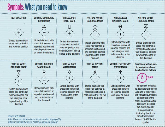
A virtual aid to navigation can be described as digital information, broadcast from an Automatic Identification System (AIS) station, to place an aid to navigation that does not physically exist in the water. Virtual aids to navigation are visible on the AIS Minimum Keyboard and Display (MKD), or as a symbol on ;appropriate display systems.
Virtual aids to navigation inform navigators about dangers to navigation and safe waterways, as well as areas where extra caution is needed, or which must be avoided. Information from virtual aids to navigation should be considered in the same way as information from physical aids to navigation.& Virtual aids to navigation can be used in the following situations:
- To immediately mark a wreck or new danger
- In areas where it is impossible to place a physical aid to navigation
- Where buoys are seasonally lifted due to ice
- When a physical buoy is off-station, e.g. due to a natural disaster
- Where a physical aid to navigation could conflict with other navigational requirements, and a virtual one meets the needs of the target group Virtual aids to navigation are not intended to replace physical buoys or beacons. However, they may be permanently deployed, following risk assessment, for example to mark a hazard that cannot be marked using a physical equivalent. They are transmitted using AIS, and are prone to the same weaknesses. Navigators and relevant shore-based personnel should be introduced to AIS aids to navigation as an extension of their training on the IALA Maritime Buoyage System.
Aids to navigation transmitted using AIS are implemented in the following ways:
- Real AIS – the AIS unit is physically fitted on the aid to navigation
- Synthetic AIS – this transmits the position of a physical aid to navigation, but the signal originates from a transmitter located elsewhere. Used where it is impossible to retain an AIS unit on a buoy or beacon due to local environmental conditions (in the rare event that the physical buoy may have shifted or be off-station, a navigator may notice a discrepancy in the locations)
- Virtual AIS – in this case, there is no physical aid to navigation at all. The transmitter is located elsewhere i.e. for marking a new danger
Virtual advantages and disadvantages
Using virtual aids to navigation brings several advantages, chief of which are greater clarity of information and immediate positive identification. They offer improvements in first response time to wrecks and other new dangers, as well as a greater range (VHF) on Radar overlay than physical aid to navigation targets, thus giving an earlier warning of danger.
Virtual aids to navigation are not prone to the weather and will always display on MKD or Electronic Chart Display and Information System (ECDIS)/ Radar overlay. They can be detected around bends and behind islands and offer a more accurate positioning.
However, they are also subject to disadvantages, mainly the fact that not all vessels are fitted with AIS. AIS is dependent on Global Navigation Satellite Systems (GNSS) , and unusual atmospheric conditions could have an effect on range.
Virtual aids to navigation systems can be vulnerable to intentional and unintentional interference or inaccuracies. For example, if a vessel’s AIS unit is malfunctioning or incorrectly installed, the mariner may not be aware of the position of a virtual aid to navigation, or may receive incorrect data.
In addition, users will not be able to fully utilise AIS aid to navigation functionality if there is no ECDIS or Radar overlay. Care must be taken where AIS is overlaid on Radar or ECDIS, as some manufacturers have chosen only to overlay ship messages.
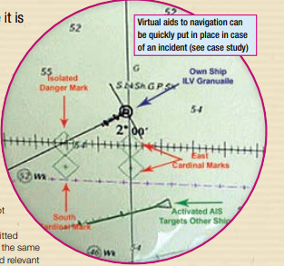
Case Study: virtual buoys in the English Channel
On 15 January 2008, the MV Ice Prince foundered 26 miles off Portland Bill at the entrance to the Traffic Separation Scheme (TSS) off Les Casquets, after losing more than 2,000 tonnes of its timber cargo. Although the wreck lay on the United Kingdom side of the median line, the area was within the French Vessel Traffic Services (VTS) coverage area of Joborg traffic.
On 17 January, ILV Granuaile commenced guard vessel duties 0.6 nautical miles north east of the wreck. The following precautions were put in place for mariners to indicate the wreck’s position:
- Navigational warnings stating the wreck’s position broadcast by the Maritime and Coastguard Agency and French Coastguard
- 1000-metre exclusion zone
- ILV Granuaile transmitting RACON morse code “D”
- South west bound traffic, on making their two nautical mile report, notified verbally of the position of the wreck by Joborg traffic
On 18 January, four virtual buoys were deployed: two east cardinals, one south cardinal and one isolated danger mark. The virtual buoys marked the wreck using the French Coastguard’s AIS base station network.
In this case, there were many accent and language barrier issues; some vessels still headed straight for the exclusion zone even after stating to Joborg traffic that they were aware of the position of the wreck.
The virtual buoys were useful because they:
- Gave early warning of the position of the wreck
- Helped alleviate language barriers providing clear information in the form of text on the MKD and overlay on ECDIS/ Radar where available
- Were easily deployed and easily removed when the wreck was no longer considered a danger to navigation
conditions could have an effect on range. Virtual aids to navigation systems can be vulnerable to intentional and unintentional interference or inaccuracies. For example, if a vessel’s AIS unit is malfunctioning or incorrectly installed, the mariner may not be aware of the position of a virtual aid to navigation, or may receive incorrect data.
In addition, users will not be able to fully utilise AIS aid to navigation functionality if there is no ECDIS or Radar overlay. Care must be taken where AIS is overlaid on Radar or ECDIS, as some manufacturers have chosen only to overlay ship messages.
Case Study: virtual buoys in the English Channel
On 15 January 2008, the MV Ice Prince foundered 26 miles off Portland Bill at the entrance to the Traffic Separation Scheme (TSS) off Les Casquets, after losing more than 2,000 tonnes of its timber cargo. Although the wreck lay on the United Kingdom side of the median line, the area was within the French Vessel Traffic Services (VTS) coverage area of Joborg traffic.
On 17 January, ILV Granuaile commenced guard vessel duties 0.6 nautical miles north east of the wreck. The following precautions were put in place for mariners to indicate the wreck’s position:
- Navigational warnings stating the wreck’s position broadcast by the Maritime and Coastguard Agency and French Coastguard
- 1000-metre exclusion zone
- ILV Granuaile transmitting RACON morse code “D”
- South west bound traffic, on making their two nautical mile report, notified verbally of the position of the wreck by Joborg traffic
On 18 January, four virtual buoys were deployed: two east cardinals, one south cardinal and one isolated danger mark. The virtual buoys marked the wreck using the French Coastguard’s AIS base station network.
In this case, there were many accent and language barrier issues; some vessels still headed straight for the exclusion zone even after stating to Joborg traffic that they were aware of the position of the wreck.
The virtual buoys were useful because they:
- Gave early warning of the position of the wreck
- Helped alleviate language barriers providing clear information in the form of text on the MKD and overlay on ECDIS/ Radar where available
- Were easily deployed and easily removed when the wreck was no longer considered a danger to navigation