

A navigator’s guide to charting, classifying and understanding restricted areas
The UK Hydrographic Office explains how restricted areas are classified and charted on paper charts and ENCs. For navigators, restricted areas are not there just for regulatory purposes – they are important features that demand recognition and understanding at every stage of the passage.
by James Weston, Electronic Navigational Chart (ENC) Technical Lead, UK Hydrographic Office
Limitations on vessel movement or activities may be imposed for many reasons – whether that is for safety, security, environmental protection or operational reasons. For navigators, restricted areas are not there just for regulatory purposes – they are important features that demand recognition and understanding at every stage of the passage.
Not all restricted areas are the same. The restrictions applied within a single area may range from partial limitations on certain, named activities to a complete prohibition on navigation or anchoring. This variety is what makes having a strong knowledge of restricted areas so important. A navigator who is unfamiliar with how restrictions are classified might assume that a charted restricted area means that all activity is forbidden. Conversely, they might not appreciate the full scope of what is and is not permitted within it.
In some cases, transit through an area is permitted but particular activities are forbidden, for example anchoring due to underwater cables or pipelines. Sometimes, the restriction only applies to certain vessel types, sizes or draughts – or only at certain times of year. Environmental protection zones, for instance, may carry seasonal constraints linked to wildlife breeding cycles or sensitive habitats, with conditions that vary considerably depending on when and how a vessel is operating. It is also common for multiple restrictions to apply simultaneously within a single area.
As well as generic restricted areas, nautical products depict several related features that impose restrictive conditions but are defined as separate feature classes. These include:
- Prohibited areas, where navigation and/or anchoring are entirely forbidden.
- Precautionary areas, namely routeing measures requiring vessels to navigate with particular caution.
- Areas to be avoided (ATBAs), often established to enhance navigational safety or protect vulnerable environments.
Although these features differ in terminology and purpose, they all impose constraints on mariner behaviour, and require clear, effective portrayal on nautical products.
Charted representation
For a navigator, the chart is often the first and primary source of information about what is and is not permitted in a given area. Restricted and regulated areas must therefore be charted clearly so that mariners can identify limitations during passage planning and while passage is underway.
The consequences of misreading or overlooking a restricted area can range from a formal incident report to environmental damage or a collision with an unmarked hazard. The methods used to convey this information differ significantly between traditional paper charts and Electronic Navigational Charts (ENCs). That is why the methods used to portray restrictions on charts and the differences between chart types are worth understanding in detail.
Paper charts
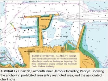
On paper charts, restricted areas are portrayed using conventions defined in International 1 (INT1) Symbols and Abbreviations used on Paper Charts. This document is standardised globally by the IHO. Area limits are typically shown in magenta, bounded by T-pecked limit lines, with symbols indicating the nature of each restriction. These symbols may be placed at intervals along the boundary, within the area itself or both. Restricted area symbols may also be combined with other features.
Where symbols alone are insufficient, explanatory notes can be added to the chart face. This gives the mariner immediate visual cues; however, the scale of the chart and the need to avoid clutter both limits the amount of detail that can be shown. A symbol may show that a restriction exists, but cannot always convey the full picture. Navigators should consult the relevant Sailing Direction/Nautical Pilot publication, which may contain further information, or contact the local authority if restrictions are still unclear.
Electronic Navigational Charts
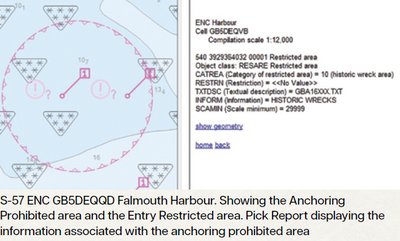
ENCs portray restricted areas through a combination of symbols and structured attribution, with full details accessible via the ECDIS Pick Report. The Restriction attribute (RESTRN) supports more than twenty standardised restriction types. Additional attributes allow for further classification or free-text description where standard values are insufficient.
When information relevant to the safety of navigation is not directly associated with a specific feature, Cautionary Areas (CTNARE) can be used. These are intended to draw attention to dangers, risks or navigational advice, such as areas of continually changing depths or uncertain bathymetry.
Visually, ENCs broadly mirror paper chart conventions, with magenta used for regulatory features. However, where multiple restrictions apply to a single area, only the first restriction symbol is typically displayed. It is essential to review the ECDIS Pick Report to understand all applicable restrictions within the area.
Clear understanding supports safe navigation
Restricted areas are critical elements of nautical charting, whether they are represented as generic restricted zones or as specific features that inherently carry restrictions. They represent decisions made by authorities about how certain waters should be used, and the chart is the primary means by which those decisions are communicated to the mariner.
Paper charts and ENCs both aim to communicate these restrictions, but through different mechanisms. Paper charts rely on static cartographic symbology and notes, while ENCs combine symbology with rich attribution to deliver a greater volume of information without increasing visual clutter. By understanding restricted areas, mariners can ensure safe and compliant navigation.
More information on how to update Admiralty Standard Nautical Charts is available at: https://www.admiralty. co.uk/charts/standard-nautical-charts#Support
See here for more information on ENC symbols and abbreviations.