

Seaways Free Article: Back to the future
Lessons from the introduction of ECDIS can smooth the S100 changeover
by Denis Hains, Ed Kuwalek, Michael Bergmann, Jordan Pratt & Jean-Luc Bédard
The Internationsl Hydropgraphic Office (IHO) S-100 hydrographic data framework became operational in January 2026 and is now actively being implemented worldwide. Implementation is not uniform from country to country, and varying levels of maturity and progress are observed across regions. However, this is not the first time the industry has faced a similar transition, and there is much we can – and should – learn from previous experience.
From paper to ECDIS
During the 1990s, the hydrographic community entered a period of equally profound transformation. The introduction of the Global Positioning System (GPS) and ECDIS marked a decisive shift from analogue to digital navigation. This transition required significant commitment to research and development, as well as the large-scale digitisation of paper nautical charts into the first generation of Electronic Navigational Charts (ENCs) based on the IHO S-57 standard.
Crucially, this transformation was not achieved by any single stakeholder. Pioneers took risks and saw prompt return on investment. Hydrographic Offices, survey organisations, industry partners, ECDIS manufacturers, and mariners collectively assumed both the risks and the responsibilities associated with adopting and operationalising these new capabilities. Their collaboration established the foundations of today’s digital maritime navigation framework and delivered several tangible outcomes; including the IHO S-57 transfer standard and its companion S-52 portrayal rules, the IMO ECDIS Performance Standards, and the Worldwide ENC Database (WEND) principles supported by the Regional ENC Coordinating Centres (RENCs). Together, these achievements have served maritime shipping very well to this day.
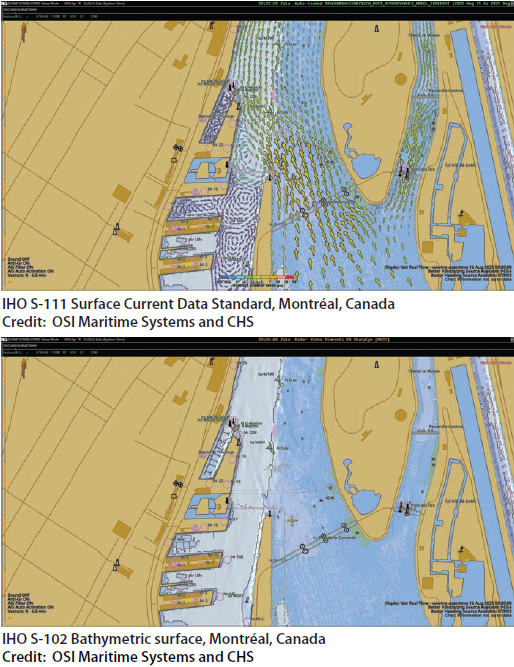
In 2026, the hydrospatial domain is once again at a pivotal juncture with the implementation of the IHO S-100 standard. Unlike its predecessor, S-100 enables the integration of multiple layers of hydrospatial data; including dynamic, near-real-time information such as high-resolution bathymetry, water levels, surface currents, sailing directions and navigational warnings; introducing a new level of intelligence and interoperability within ECDIS and beyond. This supports safer and more efficient navigation, dynamic under-keel clearance, optimised routing with reduced fuel consumption, and a broader range of maritime and ocean uses (see below).
IHO S100 data standards
- S-101 Electronic Navigational Chart (ENC)
- S-102 Bathymetric Surface
- S-103 Sub-surface Navigation
- S-104 Water Level Information for Surface Navigation
- S-111 Surface Currents
- S-112 Open - (See Decision HSSC9/38)
- S-121 Maritime Limits and Boundaries
- S-122 Marine Protected Areas
- S-123 Marine Radio Services
- S-124 Navigational Warnings
- S-125 Marine Aids to Navigation (AtoN)
- S-126 Marine Physical Environment
- S-127 Marine Traffic Management
- S-128 Catalogue of Nautical Products
- S-129 Under Keel Clearance Management (UKCM)
- S-130 Polygonal Demarcations of Global Sea Areas
- S-131 Marine Harbour Infrastructure
- S-164 IHO Test Data Sets for S-100 ECDIS
In many ways, this moment invites a compelling analogy with the movie Back to the Future; a return to a familiar point in time, yet under entirely new conditions and with far greater possibilities. As in the 1990s, the successful realisation of S-100 depends on the collective engagement of the entire hydrospatial ecosystem. Hydrographic offices, industry, technology providers, and end users must once again align efforts, share risks, and invest in innovation. Once again, we see a need for pioneers and risk takers.
A broader transformation
While the transition from paper charts to the first generation of ENCs represented a significant step into the digital era, it was, in retrospect, only an initial entry point into a much broader transformation.
In 2026, the maritime and hydrospatial domains are evolving within an increasingly data-driven environment. Efficiency gains and ROI are closely tied to the effective use of integrated hydrospatial data and data services. Today’s landscape is both more complex and more fragmented than that of the 1990s; with more stakeholders, more data sources as well as data needs, and more competing priorities – requiring even stronger alignment around global standards, quality and shared strategic commitment.
With 2029 as the target for mandatory S-100 compliance for new installations by ECDIS manufacturers, there is a risk that some stakeholders may defer action until regulatory deadlines. Treating this date as a comfortable runway would be a serious mistake. S-100 is not a switch to be flipped in 2028.
Successful adoption requires a coordinated, multi-year effort across the entire hydrospatial supply chain; from production tooling, data validation, training, and capacity building, through to S-100 ECDIS development, type approval, sea trials, system upgrades, real-time connectivity upgrades, navigator training, and fleet uptake. Proactive engagement and investment across all segments of the hydrospatial ecosystem will be essential to fully capture the benefits of this next phase of digital transformation. Compressing this into a final-year sprint risks an unstable launch built on under-tested data, immature workflows, and an unprepared user base; outcomes that could erode confidence in the standard and set the broader digital transformation back by years.
The following short list defines the work to be done over the next 12 to 24 months:
- Hydrographic offices: Move S-101 from sample areas to expanded operational coverage in priority corridors; publish overlapping S-102, S-104, S-111, and S-124 services alongside; document conversion methodology and lessons learned for global peers.
- ECDIS, chart radar and PPU manufacturers: Accelerate S-100 ECDIS development to type-approval readiness; expand support for the full Phase 1 and Phase 2 product specification set (engage early with shipping lines and pilots in operational testing).
- Shipping lines and ship operators: Identify a flagship route or vessel for early S-100 deployment; include S-100 readiness clauses in newbuild and retrofit specifications; invest in marine officer training and onboard familiarisation.
- Port authorities and pilots: Adopt S-100-compatible Portable Pilot Units and back-office systems; integrate S-100 data services into port logistics and traffic management; lead local benchmark trials in partnership with HOs and OEMs.
- Mariners and marine officers; Engage actively with vendor training programmes; provide structured operational feedback on S-100 products in service; champion the transition within bridge teams.
- Regulators and standards bodies: Synchronise national implementation plans with the IHO Roadmap and IMO Resolution MSC.530(106)/Rev.1 and the IMO Model Course for ECDIS; finalise revisions to IEC 61174 and related type-approval frameworks; support capacitybuilding for smaller hydrographic offices and developing-nation administrations.
A need for leadership
Despite ongoing IHO S-100 pilot projects in regions such as the United Kingdom, France, Australia and Canada, current efforts are still largely perceived as limited deployments or testbeds. From a user perspective, S-100-based products and services have yet to fully transition into sustained operational use and are often regarded as remaining in a prolonged pilot phase pending broader regulatory and industry alignment toward the 2029 milestone.
At the same time, the hydrospatial ecosystem and its supply chain remain highly interdependent. Effective implementation requires coordinated engagement across all components: from hydrographic surveying, to hydrographic offices and industry partners, to distributors, to ECDIS, chart radar, and Portable Pilot Unit (PPU) manufacturers, and finally to end users, including professional mariners, marine pilots, and port authorities. Only through this integrated and collaborative approach can a comprehensive and operationally viable S-100 solution be achieved in time.
Challenges and solutions
A persistent challenge in the transition toward IHO S-100 is the tendency for stakeholders to wait for others to lead. End users expect hydrographic offices and their partners to deliver fully mature turnkey solutions. At the same time, manufacturers may hesitate to accelerate development of S-100 compliant systems if the shipping industry defers investment decisions until 2029. However, it is not just a question of hardware and software. The successful adoption of S-100 requires not only technological upgrades, but also investment in marine officers in terms of training, skills development, and cultural adaptation; what we might call brainware. Some suppliers are already offering training on S-100 as it exists now, how it can be used and how to jump in sooner rather than later.
There is, of course, nothing inherently wrong with adopting a follower strategy. Many organisations will choose to invest once systems are fully mature and risks are minimised. Yet experience consistently shows that early adopters, those who lead, are usually the first to realise gains in efficiency, performance, and return on investment. This is a strategic choice rather than a constraint.
Unlike the 1990s, the conditions for transformation are already in place. The Hydrographic Offices and their partners can already produce S-100- based products and, in many cases, can transition from IHO S-57 to S-101 with increasing readiness. The regulatory framework, and S-100, is operationally available today, and could be fasttracked in areas where there are gaps. While the number of fully S-100-ready ECDIS systems remains limited, this situation closely mirrors the early days of digital navigation, when leadership from a small number of committed actors catalysed broad transformation.
This is where the analogy to the movie Back to the Future becomes particularly relevant. The hydrospatial community finds itself revisiting a familiar moment in time, one that calls for vision, collaboration, and decisive action, but now with far more advanced tools and opportunities. It does not require a large number of leaders to initiate this shift. What is needed is a small group of committed actors to step forward and define the benchmark for S-100 implementation.
What the future looks like
The path ahead is clear. The capability exists. The standards are ready. The opportunity is immediate. Rather than waiting for the 2029 IMO milestone, the hydrospatial community can choose to act now in 2026, embracing a Back to the Future moment not as a reflection of the past, but as a deliberate and proactive step toward a more integrated, intelligent, and efficient maritime future.
The first move has already been made, with the St. Lawrence River S-100 Sea Trial, hosted by Canada through the Canadian Hydrographic Service, demonstrating S-100 in realworld operational conditions (Seaways, October 2025).
By the end of this decade, fully digital, berth-to-berth navigation will be commonplace. ECDIS will be fed by live, harmonised S-100 services delivering a precise, up-to- date operational picture in real time. High-resolution bathymetry, dynamic water levels, surface currents, real-time navigational warnings, weather overlays, and digital route plans will deliver new data services to move cargo safely in all conditions, maximise vessel loading, optimise routes, and reduce emissions. Pilots and mariners will operate with a level of situational awareness that today is found only in the most advanced simulators. Ports will orchestrate arrivals as choreographed digital flows rather than sequential approximations. Just as in Back to the Future, the world we are stepping into is full of capabilities that, only a few years ago, seemed beyond reach.
The future of digital, berth-to-berth maritime navigation is not 2029, and it is not ‘someday’. It is the next 12 to 24 months of coordinated, committed work across the entire hydrospatial ecosystem. The hydrospatial community now stands at exactly the moment where we need not caution, but leadership.
AUTHORS:

Denis Hains, Dr H.C. Geomatics Sc
President and CEO, H2i Inc, guest Professor at Laval University, Canada and former Hydrographer General of Canada.
Dr Ed Kuwalek
Chief Technical Officer, IIC Technologies
Michael Bergmann
General Manager, BM Bergmann Marine GmbH
Jordan Pratt
Vice President Software Design at OSI Maritime Systems
Captain Jean-Luc Bédard
Former Vice-President, Operations at the Port of Montreal