
Free Article : Looking and Seeing
Visual perception and situational awareness for navigators
Capt Aly Elsayed AFNI
Visual perception is the brain’s ability to process and interpret visual information from the environment. In navigation, the ability to discriminate between different shapes and objects is crucial, as is the ability to recognise and recall these forms and picture them in various orientations. This is particularly important for tasks such as recognising landmarks, following specific visual tracks, or identifying hazards and targets.
Like any cognitive skill, visual perception skills can vary from person to person. Nurturing your ability to recognise and understand visual cues and engage in mental imagery takes time and consistent effort, but the good news is that, like any skill, it can be improved. While some individuals have a natural talent for it, others may need more time and practice to develop this cognitive skill.
Even once these skills have been developed, it is important to keep sharpening and maintaining them. In general, the more you see something in real life, the easier it is to visualise it – and by contrast, lack of exposure to diverse environments might limit the range of scenes or situations that you can easily visualise. Some factors specific to the maritime environment could have a negative impact on your visual perception abilities – for example long periods spent on oceangoing routes at sea without exposure to a variety of landscapes, or overreliance on screens without relating the image to the visual surroundings. Again, not everyone will experience this – but it is important to be aware of the risk, and to keep practising your skills to mitigate it.
Interpreting the visual scene
There is a great deal of emphasis on the importance of keeping a good lookout – and rightly so. But it is also important to know what you are looking at – or more formally, to be able to interpret the visual scene, and to relate it to what the charts and instruments are showing.
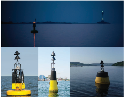
A student who has not yet joined their first ship can easily recognise the buoyage system or cardinal buoys on the charts or ECDIS because they are visually standardised. In reality, four buoys which look identical on the chart may appear very different in reality, due to their design, location and physical conditions (see images, top R).
Recognising and interpreting these differences is part of the visual perception toolset. The same tools are involved in recognising the actual appearance of buoys, channels, terminals, targets, heavy traffic, and so on in actual conditions, day or night. The symbol on the chart will always be the same – but what you actually see will differ depending on current water depths, ship position, background, traffic locations, sea state, visibility, and many other factors.
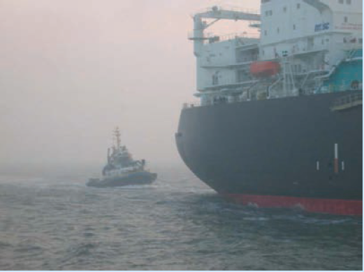
Even if there is no chart involved, what you are looking at may be quite different from what you actually see. Scale plays tricks: a bigger ship can appear closer than a smaller ship even though it is actually further away; a VLCC in ballast condition will appear larger than the same ship in fully loaded condition. A port entrance or passage between islands may appear very narrow, or even be invisible, as you approach it from the side, and only be apparent as you approach it head on – this is called parallax error. In some ports and in some vessels, it may be necessary to begin a turn before you can actually see the space you are turning into.
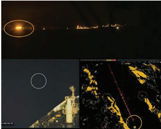
Darkness or fog make interpreting visual information particularly challenging. The images below, taken from the collision between HNoMS Helge Ingstad and Sola TS, show the same situation from different viewpoints. The top image is a screenshot of the video recording from the bridge of HNoMS Helge Ingstad, with the Sola TS marked with a yellow circle. Bottom right is a screenshot of the frigate’s radar display, with the Sola TS again marked with a yellow circle. Bottom left is a screenshot of the video recording on the bridge of Sola TS, with HNoMS Helge Ingstad marked with a white circle. Only with practice can the navigator learn how this confusion of images relates to each other, and to reality.
Visual Sequential Memory
Navigators have better situational awareness when they have a mental picture of both:
- where landmarks and navigation aids are relative to the ship (an egocentric reference frame) and
- where those landmarks and navigation aids are relative to each other (a ‘world-centred’, or allocentric, reference frame.)
Interpreting cues from visual information, including navigational aids, and using those cues to identify potential hazards and make precise decisions is known as wayfinding.
Being able to remember and recall a sequence of visual information – for example the symbols on a chart, the shape of a headland or the sequences of leading marks as you enter harbour – is essential for maintaining situational awareness while navigating. This is especially relevant when navigating through dynamic and changing environments such as port approaches and areas of heavy traffic. It is a primary aspect of successful navigation during fog or sandstorms when visual information is obstructed, or if information from navigational equipment is unavailable because of system or sensor failure (OTR/L, 2004).
Understanding and being able to picture the likely sequence of events, and what you will see at each stage, is important because your decisions should be based on a systemic view of the work – that is, on the process as a whole. ‘Decision making in the navigational context is dynamic and does not consist of discrete isolated events or processes but exists within a workflow and in an environment with multiple moving parts and numerous stakeholders. Situation assessment is an important part of decision-making, and understanding the working context surrounding the decision process is essential’. (M Lutzhoft ,A Elsayed, 2023)
Visualisation
‘Visualisation’ refers to the process of displaying and interpreting data and information in a comprehensible and useful manner. In the context of navigation, this might mean presenting data from technology such as ECDIS, radar, and other sources in a way that allows the mariner to make informed decisions.
However, ‘visualisation’ can also mean creating images within your mind, or picturing the steps within a process – what you might refer to as ‘mental practice’. In this context, visualisation helps individuals break down complex problems into manageable steps and identify solutions effectively.
Actively practising mental imagery exercises and engaging in creative activities can help individuals maintain and strengthen their visualisation skills and prepare for different scenarios. A study involving 60 aviation pilots of varying experience levels looked into the frequency, vividness, and content of mental practice they use. The results indicate that pilots use mental practice and imagery quite often and report a degree of vividness of mental imagery that is significantly higher than in the general population. (Victor Conceição, 2017) For maritime navigators, as for pilots, using visualisation can help mitigate ambiguity and enhance their ability to make informed decisions in complex and uncertain situations. Ambiguity in navigation can arise from factors such as adverse weather conditions, unfamiliar waters, or unexpected developments.
Using visual sequential memory, mariners can mentally rehearse how to execute course changes, avoid collisions, and respond to emergencies in specific situations. They can also use their experience of interpreting one situation to visualise how another one might play out – but at the same time, they must be aware of their limitations.
For example, imagine a highly experienced tanker master who is assigned to navigate through the Singapore Strait for the very first time. This renowned maritime passage is known for its complexities. They turn to the sailing directions, ECDIS, and Singapore Guide Charts. These documents give a guided visual task, filled with detailed information about the strait’s characteristics, limitations, turns, speed, depths, current traffic, guidelines, etc. The Master uses this information to prepare and envision all stages of the passage (appraisal, planning, execution and monitoring) and how they might react to various scenarios. However, they are aware that understanding this information is only as valuable as their ability to interpret it or mentally imagine it. Improving their visual perception skills is the key to unlocking the unfamiliarity of the area. The box below suggests some strategies for doing this.
Another example: it’s always a challenge to find a safe anchoring location in a busy anchorage area. Before anchoring, navigators might mentally ‘see’ the process unfold in their chosen location, considering factors like depth, bottom conditions, and proximity to other vessels and structures – bearing in mind the challenges of scale and distance outlined above. In such busy areas mariners can create a mental or graphical representation of the relative motion, allowing for informed decision-making.
In emergency situations, such as blackout or a distress call, mariners use their skills of visual perception to quickly assess the situation, visualise potential responses, and take appropriate action even if they have lost information from navigation equipment.
Sharpen your perception
No matter what your experience as a navigator, it is important to sharpen your own perception by consistently training both your eyes and your mind.
Here are some strategies to enhance your ability to create and manipulate mental images. This is a long-term plan for everyone, regardless of their level of experience:
- Practise regularly: this is a long-term plan. Dedicate time each day to engage in mental visualisation exercises
- Start simple: Begin with straightforward mental images, such as different types of ships, Colregs shapes and lights and navigation buoys; comparing them with what is in the chart or ENC. Identify the height of the tide. Try to do the same at day and night. Then try to compare objects close to you and far away. Keep doing that for long periods.
- Engage all senses: Involve all your senses when visualising, not just what you see but also what you can hear, sometimes even what you can smell.
- Practical application with real objects: Handle real objects and try to recreate their image in your mind. This will improve your ability to visualise complex objects and differentiate them from other, similar objects – eg can you locate your berth and confirm it is not occupied as you approach the container terminal?
- Optical positioning: Try to determine a vessel’s position using visual observations and references, often with the aid of optical instruments. Use this in combination with electronic navigation systems, such as radar, GNSS and ECDIS, to enhance safety and accuracy, especially in adverse weather conditions or when visibility is limited. Additionally, using optical positioning requires proper training and familiarity with navigational aids and chart reading.
- Imitate success: Learn from those who excel in mental imagery like masters and pilots and observe their techniques. For example, how you can visually measure a distance from an object at mooring station, or how the same distance looks different from the deck and the bridge.
- Observe and describe: Carefully observe and describe details in your surroundings and try to replicate these details in your mind. For example, if you are reporting targets during watch, try to visually determine the distance, bearing, speed, CPA and time of CPA. etc, and compare this with information provided by the navigation equipment.
- Progressively complex imagery: Start with simple objects and scenes, then move on to more intricate scenarios or tasks. For example, try to imagine an approach passage plan in your mind. Initially, do it step by step and then imagine it as whole. Imagine going through a buoyed channel at night, for example.
- Combine with relaxation techniques: Practising mental imagery in a relaxed state, can enhance your ability to concentrate and visualise more clearly. You can do that in the open sea, and when you have more experience, in critical situations by considering what action you would take provided you are not in charge of the operation. Don’t get distracted, and make sure you prioritise the safety of navigation at all times.
- Use guided visualisation: This process is also referred to as conceptual and spatial representation. It involves using language to construct an imaginative mental space. An effective way to achieve this is by using a thorough description of a particular space to help you recreate it in your mind. The most suitable approach for this is to use the Sailing Directions or The Guide to Port Entry for the area you intend to navigate – read them through and picture in your mind what each of them will look like. These resources offer visualisation exercises and structured imagery to guide your mental representation.
- Imagine a different perspective: Consider how the Master sees things, what the pilot looks for, or how your ship appears to targets on the radar. What aspect is visible to them? Imagining what the tug Master can see while assisting the ship – or, if you are on a tug, what the view (and your vessel!) looks like from the bridge.
Technology – pros and cons
Technology has undoubtedly changed the way we access and interpret information, which may have both positive and negative effects on visual sequential memory and the development of mental imagery and spatial representation. Overreliance on screens such as ECDIS, Radar, PPU, AIS and optical support equipment can diminish the brain’s ability to process and interpret visual information from the environment and to navigate using traditional navigational aids and landmarks. In addition, constant exposure to digital screens and multitasking can impact attention span and focus.
It’s essential to strike a balance between making good use of technology and nurturing one’s ability to engage in mental imagery. Technology offers valuable tools for checking and validating your understanding of the visual scene and strengthening your visualisation abilities. Cross referencing between bridge navigation equipment and actual visual input is vital. It can also help individuals to develop and refine their visualisation skills. Technology can be a valuable tool, but it should complement, rather than replace, our capacity for mental imagery and creative thinking.
In brief
Visual perception is a vital cognitive skill and technique for professionals in fields such as maritime navigation, aviation, defines, emergency response, and many others. Like any cognitive skill, it takes time and consistent effort to strengthen visual perception, and the effort needed to do so can vary from person to person. While some individuals have a natural talent, others may need more time – but everyone, no matter what their skill level, can benefit from dedicated practice. By harnessing the power of imagination, individuals can enhance their performance, develop their skills, and improve their problem-solving abilities.
References
Florian Jentsch, Clint Bowers,Eduardo Salas. (1997, October). Could Mental Practice and Imagery Be Techniques for Enhancing Aviation Performance?
M Lutzhoft ,A Elsayed. (2023, September 01). Improved Operator Decision-making.
OTR/L, S. N. (2004). Learning Re-enabled -2nd edition. Atlanta, Georgia.