
202541 Chart plotter mishap
As edited from TAIC (New Zealand) report MO-2024-203
Failing to plan is planning to fail
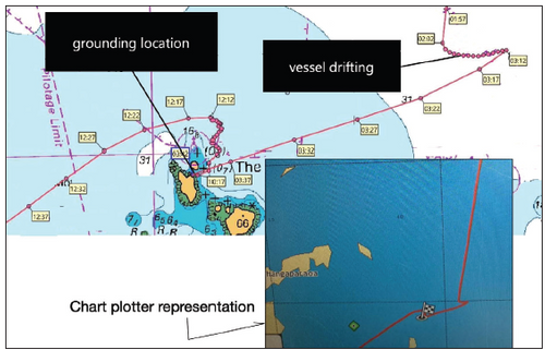
A medium sized fishing vessel with 27 crew on board drifted overnight, waiting until the next day to make their scheduled arrival at the pilot boarding area.
When the Master and the chief officer took over the watch the next morning it was still dark. Using the chart plotter, which was not an ECDIS, the Master set the course straight to the pilot boarding area. About 40 minutes later, the vessel ran aground on charted rocks at the periphery of an island at a speed of about eight knots. The vessel did not have the proper large-scale charts for the area, and the chart plotter did not show the rocks.
A small hole was observed in the bow as well as a damaged propeller. Luckily, the vessel could be refloated at high water and towed into port.
The investigation determined that the Master had based his decision on an incorrect understanding that they had safe water. Had an appraisal been conducted and a formal voyage plan prepared based on the applicable charts and nautical publications, it is virtually certain the navigational hazards would have been identified and a course set that kept the vessel clear of those hazards.
Lessons learned
- It may seem like a ‘beginner’s mistake’ not to have a proper passage plan and appropriate scale charts (or ECDIS), but the professional mariners involved in this accident were not amateurs.
- Relying exclusively on a chart plotter for positioning is obviously a mistake but other groundings have occurred while using fully compliant ECDIS. In particular, the safety depths (and/or contours) have been incorrectly entered, among others, thus showing safe water where none was for the vessel in question. See MARS 201505, 200930, 201660, 201875.
