
200928 ECDIS and AIS problems
Ecdis and AIS problems
MARS Report 200928
I recently piloted out a medium-sized, one-year-old product tanker from a top operator. The ship had no paper charts and was fitted with an integrated bridge system (IBS) with two interchangeable radar / electronic chart display information system (Ecdis) displays on the bridge with a third, separate unit, used for passage planning.
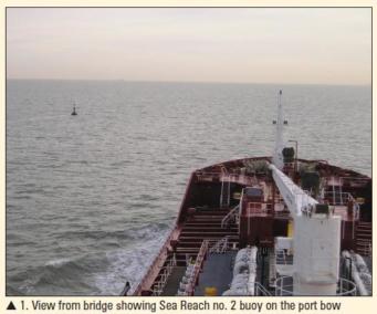
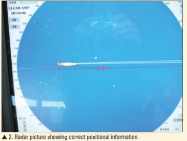
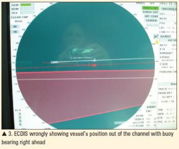
Prior to departure, the Captain explained that they had been experiencing problems with the displays. While alongside, a service engineer had changed a circuit board but, because of the terminal's radar policy, they had been unable to test the repair. One unit was set up as a radar and the other as the Ecdis and although both the displays seemed to be functioning correctly, the Captain indicated that there was still a problem. I understood this to be that he was unable to bring the Ecdis overlay on to the radar display screen. Apparently several service engineers had checked the systems but were seemingly unable to resolve the difficulty. With good visibility, I navigated the ship mainly by eye but when I looked at the Ecdis unit, I was concerned to note that the position being displayed was well over 100 m out, showing the vessel proceeding down the wrong side of the channel (see photographs). The Captain checked the back-up Ecdis unit and discovered that it, too, was displaying the same error. After about 30 minutes the position error suddenly disappeared and the chart subsequently displayed the correct position; however it is of concern that no alarms had indicated any GPS input problems during the period of the position error.
|
|
|
|
|
|
During the passage, an AIS alarm sounded and although we were still transmitting an AIS signal, we were not receiving any AIS data on any of the screens. With no back-up AIS system, this meant that there was no AIS information available to the bridge team. The Mate re-booted the systems but only a few targets were displayed while, later on, the AIS was again lost from the displays and could not be restored. The Captain explained that even when the AIS overlay was working, he found it very frustrating that it only displayed the call signs rather than the names of vessels. Having to interrogate each target and note the ships' names manually posed an especially serious problem in busy areas: a practice that he considered dangerously distracting to the bridge team. In seeking to change it, he had been told by a service engineer that it was an IMO requirement that only the call sign could be displayed in order avoid cluttering up the screen. I advised him that all the Ecdis systems that I had seen were capable of displaying the full name on the screen, rather than just the call sign. On learning this, the Captain felt seriously let down by the manufacturer's support service. While discussing the topic of AIS, he advised me that he had encountered another problem at two specific locations involving the Europlatform off Holland and the N Kish light off Dublin in which when vessels passed them, their AIS IDs changed to the ID of the mark and subsequently their data displayed as Europlatform / N Kish. Another master subsequently confirmed observing this phenomenon. Overall, this Captain was not impressed with Ecdis, even when it was working correctly. In particular, he found route planning cumbersome because, in contrast to a paper passage planning or routeing chart which could be laid out to provide an overview of the passage to be undertaken, trying to plan a route on a 17Åh monitor involved constant jumping between ranges, then having to zoom in and carefully re-check the proposed passage on the larger scale. I therefore left the vessel with a Captain extremely disillusioned with his integrated, 'state-of-the-art' bridge. His views on the concept of e-Navigation are probably best left unrecorded.