
200524 Cross Checking Positions
Cross Checking Positions
MARS Report 200524
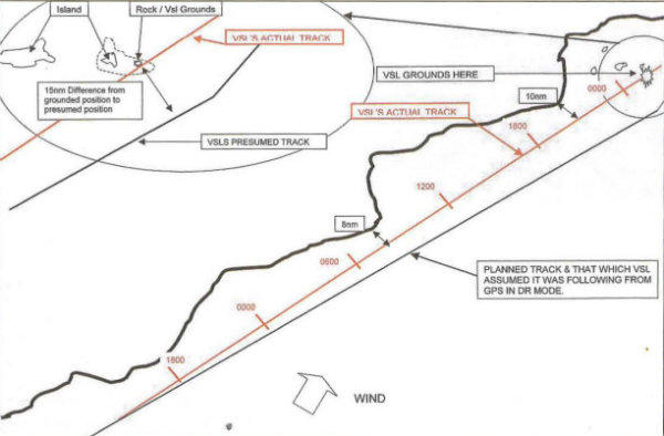
The vessel was conducting a coastal passage. The planned track would have kept the vessel approximately 20nm from land between way points before finally altering course more than 15nm off an island group. It was to follow that same course for over 30 hours. The vessel was fitted with 2 independent GPS sets and an ECDIS. The GPS which fed the ECDIS, had lost its signal and gone into Dead Reckoning (DR) mode shortly after assuming this course. This fact was not properly identified by any of the navigators. There was a constant south westerly wind, which was in fact setting the vessel slowly to the north, bringing the vessel closer to land than the planned track. As can be seen on the diagram the vessel actually came within less than 10nm of land more than once leading up to the grounding.
The ECDIS fed by GPS in DR mode was following the planned track, working from its last 'good data'. Twice in the 30+ hours on this course, the position was checked from a point of land, and the 'apparent' positions plotted coincided with the track followed by the GPS (in DR). The ship's 2nd GPS was functioning correctly. On approaching the islands, which were showing on the radar slightly off to port, the OOW assumed they must be bands of rain, as he thought he was 15nm to the SE of his actual position. The vessel ran over rocks less than 2 miles to the east of the eastern most island of the group but did not become stranded and continued on passage. After investigation, it was discovered that substantial damage was incurred to the ship's bottom, which then took several weeks in dry dock to repair with the vessel off-hire. Fortunately no pollution or personal injury resulted. The actual track of the vessel was determined later, by another system onboard which sends an independent GPS position 6 hourly to a central office ashore. The actual track was then reconstructed to show the divergence of the two tracks. See diagram.
The errors are obvious but I shall point out the main ones anyway:
- Initial GPS alarm was cancelled when going into DR mode but no action taken, and the fact was not handed over or investigated.
- Subsequent watches did not identify that the GPS or ECDIS were in DR mode despite ECDIS showing this fact. Personnel were not sufficiently familiar with the equipment.
- The two independent GPS sets were not routinely compared.
- Genuine and routine fixes were not taken from land. Where possible this should have been their primary fixing method only backed up by GPS! How the two fixes from land that were plotted were obtained is any ones guess, as they agreed with the DR track!
- Radar tuning and adjustment of clutter would have made the OOW realise that this was in fact land he was detecting. At the very least it should have made him double check his position by other means and call the master.
Obviously it is a worry that the GPS can go into DR mode in such a way and mislead its user, perhaps with an inadequate alarm for this serious failure. Should it "re-alarm" systematically or not go into DR mode at all is perhaps something that should be discussed further by the governing bodies.
However, the real concern here is the lapse in basic navigational skills and the onboard management of the standard/company navigation procedures, with regards to the over reliance on a single GPS. Better use should be made of radar, echo sounder, common sense, experience and even the secondary GPS. All would have alerted the OOW to the danger not only immediately before scraping the rocky bottom but over the whole previous day.