How AIS works and what it does
IALA regulates the global usage of AIS.
Here, IALA Deputy Secretary-General Omar Frits Eriksson and Technical Operations Manager Minsu Jeon look at the evolution of AIS onboard ships and examine its uses on SOLAS and non-SOLAS vessels, as well as the pros and cons of this versatile piece of technology.
Automatic Identification System (AIS) is a communications system that uses four worldwide channels in the VHF maritime mobile band to exchange navigation data. It came into being as a direct result of the need for heightened safety at sea. Following several maritime accidents, it became clear that a mechanism that could provide precise location details of ships was sorely needed, especially in traffic-intense zones or adverse weather conditions.
AIS automatically transmits key details about a vessel, including dynamic information, such as vessel position, heading, speed and rate of turn, provided by sensors onboard the vessel, plus static information, such as the ship’s name, cargo and destination. There are numerous AIS devices, known as stations, which are identified by a unique Maritime Mobile Service Identity (MMSI)2. Each one uses an international open standard to communicate.
AIS stations are designed to operate autonomously, without requiring human interaction, whether from ship or from shore personnel. They may be instructed to transmit in a different manner – for example, they may be interrogated (polled), or be commanded to transmit more regularly, or on a different frequency (assignment).
Legal aspects of AIS
Carriage of AIS is mandated under SOLAS. In addition, AIS is required domestically on non-SOLAS vessels by some administrations.
AIS on SOLAS vessels must provide:
- Information exchange between vessels within VHF range of each other, to increase situational awareness
- Information exchange between a vessel and a shore station, such as a VTS, to improve traffic management in congested waterways
- Automatic reporting in areas of mandatory and voluntary reporting
- Exchange of safety related information between vessels, and between vessels and shore station(s).
The development of AIS has expanded to include such devices as AIS for marine aids to navigation (AIS AtoN), AIS on search and rescue aircraft and AIS search and rescue transmitters4 (AIS-SART)
SOLAS vessels
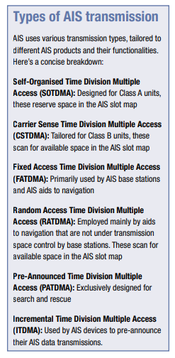
SOLAS vessels must carry a Class A AIS transponder. These operate using SOTDMA broadcast mode (see break-out box) and transmit at a power level of 12.5 watts. Dynamic information, such as position and course, is transmitted every two to 10 seconds while underway, and every three minutes while at anchor. Static and voyage related information, such as the vessel’s name and cargo, is transmitted every six minutes. Class A AIS transponders must have a DSC (156.525 MHz) receiver, external GPS, heading and rate of turn indicator, and can also transmit and receive safety-related text messages.
Non-SOLAS vessels
Non-SOLAS vessels may carry Class B AIS transponders. These operate using CSTDMA broadcast mode and transmit at a power level of two watts. Dynamic data is transmitted every 30 to 180 seconds, while static data is transmitted every six minutes. A DSC receiver and heading are optional. Transmitting safety-related text messages is also non-compulsory, and only available if pre-configured into the Class B AIS transponder. Due to the fact that position data is updated less frequently, it may be less accurate for these ships than for SOLAS vessels. Bear in mind that, while many non-SOLAS vessels (including yachts and fishing boats) do carry AIS transponders, many do not. Even if they do, they may be switched off, for example to keep fishing grounds a secret. Do not rely on AIS data to make decisions – it is there to help you, but you should use the radar and the window as your principal sources of information!
Benefits of AIS
- Enhanced safety: AIS assists in collision prevention. OOWs and maritime traffic managers can track the trajectory of proximate vessels, anticipate potential collision areas and take preventive measures in good time.
- Traffic management: AIS is invaluable for ports and harbours as it assists in organising incoming and outgoing traffic. This guarantees efficient berth allocation and refines traffic movements.
- Search and rescue: Should a ship face distress, AIS signals can direct rescue teams accurately, potentially saving lives.
- Data collection: Being digital, AIS data can be archived and studied, aiding in route refinement, fuel conservation and other maritime analyses.
Limitations and considerations
- VHF limitations: Given its dependence on VHF, AIS has a typical range of up to 20 nautical miles and in some circumstances more. However, satellite integrations are bridging this gap, introducing Satellite-AIS or S-AIS.
- Data precision: The accuracy of static AIS information hinges on the data input by the ship’s personnel. Incorrect inputs yield inaccurate broadcasts.
- Over-reliance: Relying excessively on AIS can breed negligence. AIS should enhance, not replace, traditional navigation methods and watchfulness.
Into the future
AIS has proven instrumental in enhancing maritime safety, assisting in SAR missions and serving many other purposes. Nonetheless, it is imperative to recognise its limitations, such as constraints related to VHF range, vulnerability for cybersecurity and occasional data inaccuracies. That said, AIS remains a shining example of how technology can revolutionise maritime operations. It underscores the sheer magnitude of technological potential in fostering safer and more efficient global transportation. The evolution of AIS is driven persistently by technological breakthroughs. Satellite-AIS, for instance, has expanded its operational extent remarkably. On the horizon, VDES emerges as the next evolutionary step, announcing as AIS 2.0 for a future-ready maritime world.

