
200552 AIS Inaccuracies
There have been some more reported inaccuracies in AIS data displayed by vessels. The data from a container vessel heading for Genoa suddenly changed into a vessel engaged in fishing, draught 28.5M and bound for Casablanca. The IMO number and ship's name did not change. Some 15 minutes later, the details had reverted to the correct data. It could be that the OOW was resetting the transponder and it had reverted to default settings in the process.
On another occasion, a harbour services vessel working in a UK port turned into a 220M long vessel heading for Casablanca and showing the default MMSI. This continued for four days until a message was passed to the vessel pointing out the error.
The following reports are just two taken from the NI AIS forum on the website. www.nautinst.org/ais
"The information provided by AIS can not be trusted. In many cases this information can be directly misleading and, if not correctly evaluated and verified by other means, dangerous. Wrong "chart datum" combined with wrong heading can lead to assumptions of safe CPA in narrow fairways, and in reality there might be a CPA = 0.
If these situations happen when the radar visibility is limited (like heavy rain or bad sea conditions) wrong AIS information is dangerous as the verification of the actual position of the target is missing.
In general however AIS is a fantastic aid to navigation, and if correctly used provides excellent information on other targets, sometimes way before this information can be obtained by radar. AIS also provides the navigator (pilot) with fast updates on changes made by other ships, such as heading and speed. It must also be noted that all ships are not equipped with integrated ECDIS even though they are equipped with AIS. In such situations, the use and handling of AIS information becomes more difficult, and the AIS can not be used to its full extent, thus losing its meaning to the navigator.
The observations below are a few made during only a week.
· Destination and ETA not updated or missing. We need this information whenever there is a choice of direction for the ships to go, i.e. outside Hong Kong where the ships leaving East Lamma Channel have a choice of where to go, either towards Taiwan Strait or head south. It affects our own tactics. Over 75% fail to update this information. Bad routines or are they just are slack?
· Ship's data are missing. Call sign, Vessel type, IMO number, Draught, Ship's size. Vessel type and size is something we can use for identification. Less than 10% are without this information.
· Offset of position. Is this because of wrong input of geodetic datum? These offsets can vary up to 3 cables. In these cases the CPA will not be correct. Estimated 25% has an offset that is significant.
· Wrong heading. Some ships certainly do not have any input from gyro as their heading can be up to 180° wrong. Less than 10% have this fault.
We feel that AIS is a very useful tool if used with common sense. The vector presented is often much better than the radar vector, especially during a course alteration when it updates much faster. We consider it very important to be able to identify and to find out the destination of a ship. The AIS also has the benefit of detecting ships behind land or around corners."
*********************************************
"We have recently installed an AIS system on our PSV operating in Bass Strait, Australia. The first thing I noticed was that 30% - 50% of the ships detected were not using their name but putting their MMSI number in both name and MMSI positions. I wonder how many ships would reply to a call on channel 16 to a MMSI number (how many OOW's would recognise their own number)".
**********************************************
"Vessel was lying at anchor in Bay. Vessel's AIS appeared to be only transmitting her MMSI number. As other vessels passed, namely local ferries, their AIS identity appeared to transfer to, and be held by, the anchored vessel. Once the ferries were some distance from the anchored vessel, their full AIS signal resumed, which meant there were now two similar named vessels on the screen. This scenario was repeated the whole time the vessel was in port".
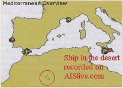
The following picture is a light-hearted illustration of what can go wrong, reproduced by kind permission of Safety at Sea International and AISlive.com.
A recent survey was carried out by the Seafarers International Research Centre (SIRC) at the U.K. Dover Coastguard Channel Information Service. About 10% of the ships transmitting AIS data revealed discrepancies, mostly on destination and draught. In view of these continuing errors being reported on some AIS equipment, it is strongly recommended that AIS should only be used as a situational awareness tool and that the radar should be the primary tool used for collision avoidance. RB.
Readers' Feedback January 2006
This Feedback comes from the Washington State Department of Ecology
This ship came to the attention of the Ecology Department staff when they noted that it appeared to be crossing the separation zone (purple shading) across the direction of traffic. The traffic lanes trend west-northwest to east-southeast, while the heading display for this ship (reportedly outbound for Longview, Washington) indicated it was heading northeast at about 14 knots.
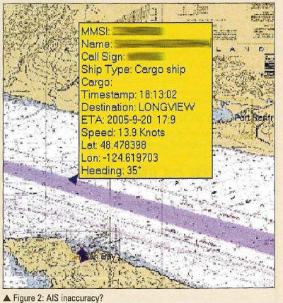
Based on visual monitoring of the movement of the ship's mark on the AIS display and comparison to another vessel's movement tracking display, it was ascertained that the ship was actually moving west-northwest in the traffic lane, not northeast as shown by the AIS heading information.
Further monitoring showed the ship turning toward the southwest as it exited the traffic lanes, while the heading information continued to be offset by more than ninety (90) degrees!
The lessons learned are that:
1) AIS equipment needs to be calibrated, tested, and maintained in conformance with manufacturer's directions and regulatory requirements in order to avoid confusion for those using an AIS display.
2) Mariners must not rely solely on AIS data for information on the movements of vessels with which they interact.
3) Vessel operating companies should ensure that their Safety Management Systems (SMS) require personnel to be trained in using and maintaining AIS systems installed aboard their vessels.
4) Vessel operating companies should ensure that their Safety Management Systems (SMS) include pre-departure checklists that require that AIS equipment be checked for proper operation and inputs prior to getting underway and post-arrival checklists that require that AIS be adjusted to transmit the correct status of the vessel after anchoring or making berth.